Google maps is one of the most incredible geolocation tools ever. Not only does it help us to know where a specific place is, but it also helps us to reach it through the shortest route. Do you want to know how to get to X starting from Y in the shortest possible time? Google Maps is the best tool for this.
How to get anywhere with Google Maps by car, public transport, walking or cycling
So that Google Maps can locate us on the map and help us establish a route, it is necessary activate the location or GPS service of our phone. In the case of Android, we can do this in 2 different ways:
- From the notifications menu, activating “Location”On the quick setting panel.
- From the settings or system configuration (gear icon), in "Settings -> Personal -> Location”.

Now that we have the location activated, let's go “to the nougat”.
1 # Open Google Maps
We can find the location of a place by typing the address in the browser's search engine or with the Google Assistant itself. The Big G company offers several avenues to use their tool, which is appreciated.
In any case, to start the process the simplest thing is simply open the Google Maps app.

 Download QR-Code Maps - Navigation and Public Transport Developer: Google LLC Price: Free
 2 # Find the destination
Once inside the application, we will see a map with a blue circle that represents our current location. Just above the map we find a search engine with the legend "Search here”.
The first thing to do is click on the search engine and write the address or name of the place we want to get to. We can also click on the microphone icon to perform the voice search order.
If there are several possible destinations, these will be shown with a red pin. We simply click on the red pin –our destination-, and immediately a blue button will appear with the legend “How to get”At the bottom of the screen. We click on it.

3 # Set your transportation method
Now a new screen will be loaded with the various methods of transport and the fastest routes to get to the requested address.
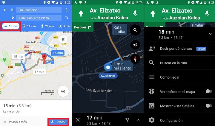
The route marked in blue corresponds to the shortest route. Other alternative routes will be marked in gray or brown to differentiate them from the main route. We can also see the distance in km and the duration of the journey, right at the bottom of the map.
Depending on our method of transportIn the top menu we will see several icons that we can click to see the best routes for car, public transport, bicycle or to go on foot.
Car or road
This is the default transportation method, the car. Our location is represented by a blue icon with the drawing of a car, which is updated as we move.
To obtain an assisted guide we just have to click on "Start”. Next, a new window will be loaded that will indicate the turns and streets that we must take in real time.
 Walking
 Walking
If we are within a city or town, sometimes walking is the best solution. Our location is represented by a blue icon with the drawing of a pedestrian, and the routes are small circles that mark the way forward.
If we click on "Start”We will obtain an assisted guide with a new, more detailed map.
Cycling
In case of cycling, if we click on start, we will be loaded with a map similar to that of "pedestrian mode", with voice prompts suitable for cyclists.
Public transport
Finally, if we prefer to use public transport, Google Maps also offers us information in this regard.
If we click on "Choices”Within the public transport menu we can choose between several modes: bus, metro, tram or train. We also have the option of selecting a route according to these criteria: "Best route", "less transfers" or "Walk less".

Once we choose one of the alternatives, if we click on “Start”, We will be shown the path that we must travel on foot until we reach the corresponding stop, the subsequent route that the transport vehicle will make, and the subsequent walk until we reach our destination.
4 # Check the route and move on the map in real time
From here, as we move towards the indicated destination, Google Maps will update our position. Remember that the destination will be indicated with a red pin.
The truth is that Google Maps has improved a lot with the successive updates it has received over the years, becoming a more than convenient tool. Especially if we are in a city that we do not know, as a tourist, or we simply want to get to a specific place in the shortest time possible.
You have Telegram installed? Receive the best post of each day on our channel. Or if you prefer, find out everything from our Facebook page.